Exploring the Spectacles of Ho Chi Minh Highway
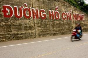
The Ho Chi Minh Highway is known as a treacherous road. But to many, encountering the danger is worth to experience the spectacle that embraces its every curve. Extending across the provinces of Thua Thien-Hue and Quang Nam, the road is made up of hundreds of kilometres of high mountains and deep valleys. A drive through this highway will acquaint you both of sad history and beautiful wonders.
The highway, more than 745 miles of which are already open to traffic, begins at the gates of ${bigcity_Hanoi:"Hanoi"}, the capital, and ends at the doorsteps of ${bigcity_Ho_Chi_Minh_City:”Ho Chi Minh City”}, which was known as Saigon when it was the former capital of South Vietnam.
The road passes through many places, all named with the letter “A”. When used alone, “A” means absolutely nothing. Buffered to pair with another word, “A” helped name many places along this highway, each cradling its own story, culture and appeal.
A Luoi, A Sau, A Bia and A Co are known the "fire lands" during the American War. At present, these lands evoke the peace of bright airy realms that connect with many other regions. Almost all traces of American presence in A Luoi, where US troops were once stationed, have vanished. Only the old people can point out the helicopter landing field. Surrounded with high mountains, the valley is now flanked with tranquil towns and cheerful villagers. The laughing youngsters who crowd around the foreign visitors know very little about the war.
At some places like the A Shau valley town of A Luoi, a mini-boom is clearly afoot. Here, you will see a bustling market selling baskets of fruit, Japanese watches and delicious French bread, and newly built houses abound.
In addition to A Sho is another of the known stations of enemy troops among the many other smaller ones. The A Sho station was knocked down in 1966 by the liberation force. From 1969-1970 the Americans had to withdraw from other posts.
A Luoi is adjacent to Khe Sanh – a well-known US base during the war and destination of many tourists, especially those who have experienced and wanted to search for their memories of war. To meet the tourists' accommodation demands, these districts have made available several hotels, motels, guest houses and restaurants.
A Luoi can be reached by a 2-hour motorbike ride from Hue along Highway 49. Passing the 63km long highway section of Highway 49 are three passes: Kim Quy, Ta Luong and A Co. A Co is a 15km long dangerous but impressive trail, with countless sharp curves.
In Hong Quang and Nham communes adjacent to the border station, green coffee plantations are spread out. About 20km from A Luoi to the south is A Roang Tunnel. In A Roang, Huong Nguyen and Hong Ha, large rubber plantations expand throughout the region.
A Pat, A Moong and A Tep have a very exciting landscape of imposing heights and a grandeur of the primitive forests.
From A Vuong Bridge, travelers will be acquainted with a new road upstream where a lot of folklores and myths are strongly rooted. These include the story about Colau Bhlao (who had built a road). The A Vuong River running below the high mountains in Ma Cooih Commune accumulates water here to serve the A Vuong Hydro-electricity Plant – a main electricity supply in the Central region.
A So is the last of a series of names beginning with the letter A along Ho Chi Minh Highway from A Luoi District of Thua Thien-Hue to Quang Nam.
Ho Chi Minh National Highway, probably the country's best and the largest public works project since Vietnam War ended 30 years ago. The transformation of the road which used to cradle sad history into highway is an apt metaphor for Vietnam's own journey from war to peace. Many more stories will unfold as you round the curves on this highway’s many steep mountain passes. It is difficult to cite all the spectacles that await visitors here, but it would be interesting for anyone who has the opportunity to explore this land of many myths.


